


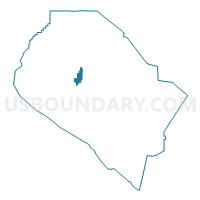
Voting District 13266, Orange County, California
About
Outline

Summary
| Unique Area Identifier | 535810 |
| Name | Voting District 13266 |
| County | Orange County |
| State | California |
| Area (square miles) | 3.63 |
| Land Area (square miles) | 3.62 |
| Water Area (square miles) | 0.01 |
| % of Land Area | 99.81 |
| % of Water Area | 0.19 |
| Latitude of the Internal Point | 33.72098330 |
| Longtitude of the Internal Point | -117.85707420 |
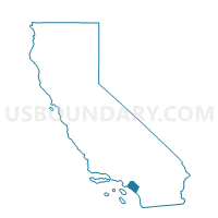
Maps

Graphs
Select a template below for downloading or customizing gragh for Voting District 13266, Orange County, California


Neighbors
Neighoring Voting District (by Name) Neighboring Voting District on the Map
- Voting District 11021, Orange County, CA
- Voting District 11031, Orange County, CA
- Voting District 13201, Orange County, CA
- Voting District 13206, Orange County, CA
- Voting District 13221, Orange County, CA
- Voting District 13226, Orange County, CA
- Voting District 13251, Orange County, CA
- Voting District 13271, Orange County, CA
- Voting District 13276, Orange County, CA
- Voting District 13281, Orange County, CA
- Voting District 22046, Orange County, CA
- Voting District 33236, Orange County, CA
- Voting District 33241, Orange County, CA
- Voting District 33286, Orange County, CA
Top 10 Neighboring County Subdivision (by Population) Neighboring County Subdivision on the Map
- Anaheim-Santa Ana-Garden Grove CCD, Orange County, CA (1,648,519)
- Central Coast CCD, Orange County, CA (246,125)
Top 10 Neighboring Place (by Population) Neighboring Place on the Map
- Santa Ana city, CA (324,528)
- Irvine city, CA (212,375)
- Costa Mesa city, CA (109,960)
- Tustin city, CA (75,540)
Top 10 Neighboring Unified School District (by Population) Neighboring Unified School District on the Map
- Santa Ana Unified School District, CA (255,137)
- Newport-Mesa Unified School District, CA (195,345)
- Tustin Unified School District, CA (131,557)
Top 10 Neighboring State Legislative District Lower Chamber (by Population) Neighboring State Legislative District Lower Chamber on the Map
- Assembly District 70, CA (496,195)
- Assembly District 68, CA (431,683)
- Assembly District 69, CA (412,205)
Top 10 Neighboring State Legislative District Upper Chamber (by Population) Neighboring State Legislative District Upper Chamber on the Map
- State Senate District 33, CA (936,082)
- State Senate District 35, CA (899,261)
- State Senate District 34, CA (845,951)
Top 10 Neighboring 111th Congressional District (by Population) Neighboring 111th Congressional District on the Map
- Congressional District 48, CA (727,833)
- Congressional District 46, CA (648,663)
- Congressional District 47, CA (631,422)
Top 10 Neighboring Census Tract (by Population) Neighboring Census Tract on the Map
- Census Tract 755.15, Orange County, CA (15,295)
- Census Tract 742, Orange County, CA (9,450)
- Census Tract 746.02, Orange County, CA (9,156)
- Census Tract 740.04, Orange County, CA (7,444)
- Census Tract 740.05, Orange County, CA (7,432)
- Census Tract 639.07, Orange County, CA (6,994)
- Census Tract 745.01, Orange County, CA (6,880)
- Census Tract 744.07, Orange County, CA (6,700)
- Census Tract 744.05, Orange County, CA (5,820)
- Census Tract 744.03, Orange County, CA (5,688)
Top 10 Neighboring 5-Digit ZIP Code Tabulation Area (by Population) Neighboring 5-Digit ZIP Code Tabulation Area on the Map
- 92707, CA (59,492)
- 92780, CA (57,741)
- 92701, CA (53,908)
- 92626, CA (49,341)
- 92705, CA (44,706)
- 92614, CA (24,748)